


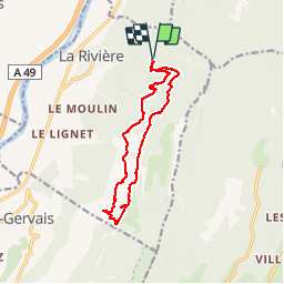
Pied FraisLe Rivet Par le Pas du Versoud

psesjs
User

Length
13 km

Max alt
1235 m

Uphill gradient
742 m
Km-Effort
23 km

Min alt
708 m

Downhill gradient
740 m
Boucle
Yes
Creation date :
2015-05-10 00:00:00.0
Updated on :
2015-05-10 00:00:00.0
4h50
Difficulty : Very difficult

FREE GPS app for hiking
 SityTrail
IGN / Geographical institutes
SityTrail Plus
The world is yours!
About
Trail Walking of 13 km to be discovered at Auvergne-Rhône-Alpes, Isère, La Rivière. This trail is proposed by psesjs.
Photos


Positioning
Country:
France
Region :
Auvergne-Rhône-Alpes
Department/Province :
Isère
Municipality :
La Rivière
Location:
Unknown
Start:(Dec)
Start:(UTM)
698322 ; 5012373 (31T) N.
Comments